A CAD based Architectural Information
|
Erwin Heine |
A CAD based Architectural Information
|
Erwin Heine |
Ph.D., Graz Technical University, June 1997
|
||
 |
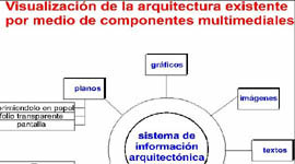 |
The incorporation of the hierarchical structure of architectural elements
in the computer model allows for the definition of highly complex element-specific
queries.
Apart from the possibilities of visualization already described this new
approach has also resulted in the creation of a powerful tool for structural analysis.
Dimensional analyses can be performed according to elements or other
criteria, their efficiency and significance being enhanced by precise measurements,
convenient selection of individual dimensions and the possibility of direct transfer to
data base systems and programs of statistical analysis for further processing.
The same applies to investigations on the alignment of buildings and
squares or differences in the levels of habitation layers.
The second part of this work deals with an practical application of this
method.
The potentiality of modern computer-aided design and the call for plans for
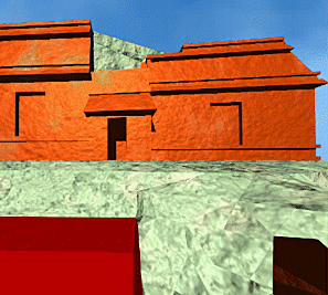
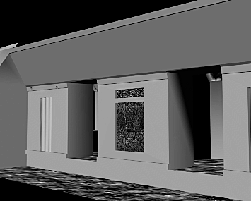
the Maya-site of Santa Rosa Xtampak led to the geodetic/photogrammetric work with the aim
of producing - for the first time in the history of Maya-resarch - a three-dimensional
„digital architecture model" of a Maya-building.
It will be described the surveying method and the three dimensional
computer-modelling of an ancient Maya-structure, just as the application of animation
software for its presentation and reconstruction. The possibility of dynamical
visualization in form of „virtual walk“ or „virtual fly over“ offers
thorough and realistic visual impression of the building.
.