 |
3D - Documentation of |
Erwin Heine |
|
3D - Documentation of |
Erwin Heine |
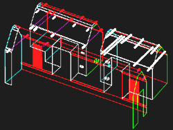
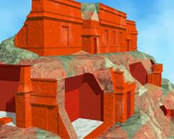
Project History In 1989 and 1992 the geodetic surveyors Erwin Heine and Andreas Reiter from the Technical University Graz, Austria, carried out a careful geodetic-photogrammetric survey of the Temple-Palace, with the aim of producing a three-dimensional "digital architecture model" of a Maya-building. .... of the work of the Geodetic Surveyors In 1989, initiated by Nicholas M. Hellmuth and promoted by Robert Kostka from the Graz University of Technology, the graduate students Erwin Heine and Andreas Reiter started the geodetic photogrammetric documentation project for the Palace of Santa Rosa Xtampak (Heine, Kostka, Reiter, 1990). In August 1989 Heine and Reiter visited the ruins for the first time, together with Manuela Reiter and Michael Zenz. Erwin Heine was awarded by the Ministry of Science and Research in Vienna with a research Master's scholarship for Scientific Research in Foreign Countries. To carry out the measurements in the field further support was provided by the Foundation for Latin American Antropological Research (FLAAR) as well as by Linda and William Folan from the University of Campeche. The "Instituto National de Antropologia e Historia" of Mexico issued the permission for the geodetic work at the archaeological site of Santa Rosa Xtampak. From the 26th of July until the 15th of August the team was taking their measurements for the 3D documentation of the Palace. One of the main aims was the exact geodetic documentation of the two unique staircases within the Palace. This task proved extremely difficult because of their narrowness and steepness. Therefore a method combining theodolite and precise laser mapping techniques was selected to chart its geometry. Some facade elements and its almost collapsed sections were recorded by means of stereo pictures. These amorphous surfaces were analyzed applying equidistant contour lines. The 3D capability of computer-aided design (CAD) systems enabled a precise three-dimensional documentation as well as a shaded visualization of the winding internal staircases and the partly collapsed three-story façade of the Palace (Heine & Reiter 1990, Heine, 1992; Reiter 1994). In 1992 the Austrian Scientific Research Fund (FWF) awarded a common project applied at by Heine and Reiter together with Hasso Hohmann to further develop the documentation methodology and apply it for the rntire Palace (Project Nr. P8928-GEO/PHY). From the 8th until the 27th of November 1992 Heine and Reiter revisited the site together with Angeles Cervantes Alarcón de Heine and Erhard Gruber to complete the precise 3D documentation of the Palace. Based on this geodetic and photogrammetric data the digital processing of the 3D-CAD model was carried out by Erwin Heine with support from Andreas Reiter at the University of Technology in Graz (Heine, 1995). Later on he continued his research towards a doctoral degree at the same University under the supervision of Gerhard Brandstätter and Annegrete Hohmann-Vogrin (Heine 1997). Erwin Heine's work is probably the first use of cyberspace technique in the three dimensional documentation of Maya architecture. The resulting three-dimensional "digital architecture model" allows the scientist (architect, archaeologist) to single out and thoroughly study any interesting part of the structure in form of sections, axonometric views or even virtual "walk-through". History......description...... image libary......theory (dt/e)...... publications |